


Deeper Oakland: A Salinian Jaunt
Plus July walks, including a new workout ramble, and a look at some human stratigraphy

Hello Subscribers,
In June I went to the Salinas Valley to return two stones to the places I collected them. One is a piece of granite I picked up at a roadcut on Bitterwater Road, in the Gabilan Range, one summer day in 2004. Earlier that day I’d lunched in King City, at the brand-new Spanish Peaks Brewery at the end of Broadway Street. Unaware the company had moved here from Bozeman, overlooked by the Spanish Peaks range, I assumed the name referred to the Pinnacles. The brewery is long gone with only a pint glass in my cupboard to remember it by, but the roadcut looked exactly the same.
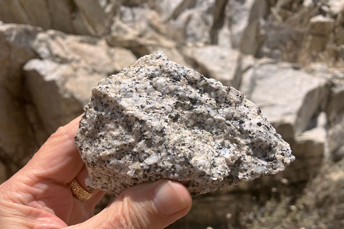
This rock, a picture-perfect granite, has paid its own way—I sold images of it to textbook publishers—so I was properly thankful as I tossed it up onto a ledge, where it will sit until the next earthquake sends it back down to the roadside.
The other rock is a hand specimen of the Sierra de Salinas Schist, an understated beauty consisting of a creamy tan matrix glittering with a thousand small mica crystals. It’s a sibling of the Rand-Orocopia schists, a belt of odd rocks extending from Southern California into Arizona considered prime evidence of tectonic underplating during the region’s time as a subduction zone.
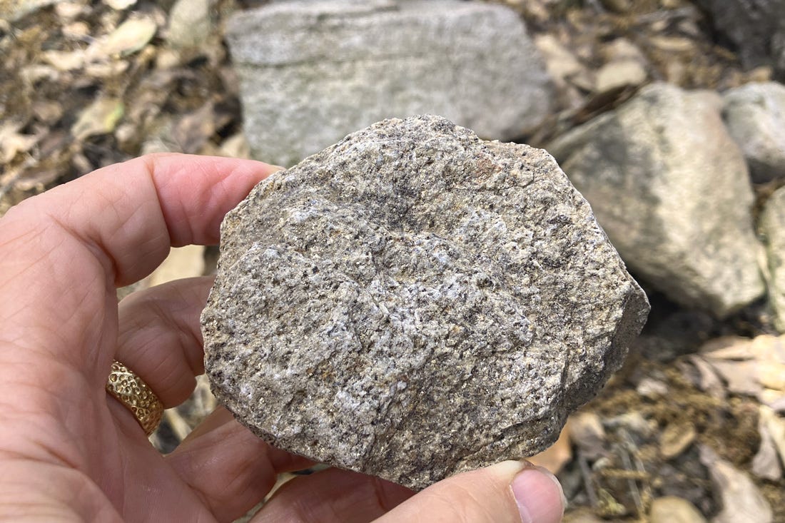
Now it’s back under its oak tree in a canyon at the end of Limekiln Road, in the Santa Lucia Range. Movement on the San Andreas fault system carried both of these rocks far to the north from the south end of the Sierra Nevada as part of the Salinian terrane. Other parts of the Salinian block include Monterey, Big Sur, the Santa Cruz Mountains, Point Reyes and Bodega Head, but the Salinas Valley is a special place all its own.
Events
The inaugural Castle Canyon walk went well. I think I’ll do it earlier in the spring next time when the flowers are better. The fact that the walk happened on the day of a lively street festival gave me an idea.
In July I’ll be leading two walks. Both of them will avoid the scheduled shutdown of the north Oakland BART stations on July 20 and 21.
Saturday the 13th I’m introducing what I think of as a workout ramble in the belt of gravel foothills I call the Fan. The 3.3-mile route starts near the 19th Street BART station and ends near the MacArthur BART station, which is what makes it a ramble rather than a loop. What makes it a workout is all the stairways and paths on the western side of Adams Point and the Glen Echo Creek valley, in the Piedmont Avenue neighborhood. There will also be geology along the way as well as historic neighborhoods and hidden green spots in some of Oakland’s most charming topography, land with a million years of history. The endpoint, Telegraph and 41st, will be the site of the annual Temescal Street Fair, offering options for extra fun. Tickets here now.
On Saturday the 27th I’ll present my Geologist’s Walk Around Lake Merritt, a perennial favorite. I expect to repeat it one more time this year, in September or October. Tickets here now.
Book News
Three issues ago, I mentioned that Deep Oakland had been named a finalist for a California Book Award in the Californiana category. I also said I didn’t expect to win, but still felt greatly honored. The winning title, announced early in June, is Rosanna Xia’s excellent California Against the Sea, which I praised in this newsletter a year ago. It deserves to be widely read, and the author got celebrity attention at the Bay Area Book Fair.
But there’s still nice news for my book. I’ve been told that Deep Oakland will come out in paperback next spring with a new cover. I’ll always love the hardbound edition more, though, and I expect to lay in a supply to sell in person.
That reminds me, I still haven’t heard about any of the seven copies I put in Little Free Libraries last year, with this sticker inside. I hope they’re circulating as intended.

Q&A
Moe was scrutinizing the excavations around Gilman and I-80, in north Berkeley, and thought the various layers exposed looked a lot like stream deposits. And they do! There’s even a small stream there inside the culvert along the bottom.
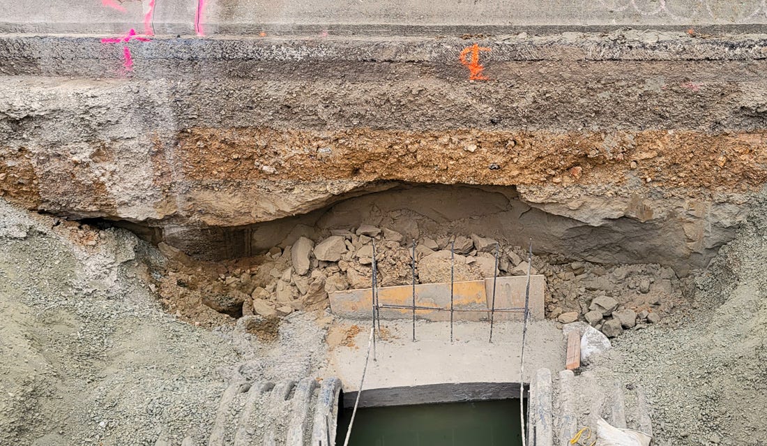
But everything in the picture is landfill. All of I-80 is built on artificial land, what used to be coastal marsh. Each layer represents a human intervention some time between 1900 and now meant to turn soft ground firm. Moe was able to date some of the debris with abundant online help, like this guide to Hazel-Atlas glassware. Oakland had a major Hazel-Atlas glassworks, fed by mines of pure quartz sand from the Antioch-Pittsburg area.
As always, thanks for reading.
Andrew
The July 27 walk is cancelled; insufficient people have signed up. That's all right, it's hard to compete with summer and the Olympic Games and a happy burst of political activism.
I didn't mention it in the newsletter, but the July 13 walk will be FREE.